tl;dr / Summary
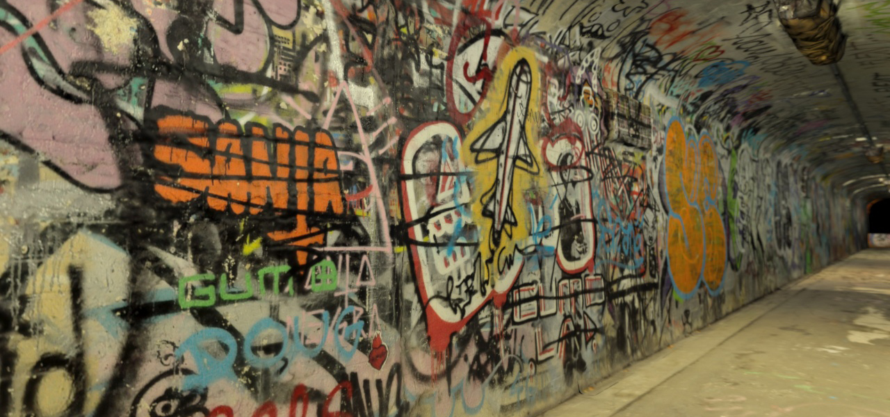
Tactical Space Lab has just completed a ground-breaking gigapixel reconstruction of Trafalgar St Tunnel, one of Sydney’s most vibrant graffiti spots. The reconstruction has been released as a free iPad app, allowing visitors to explore the 35 meter long tunnel and examine whatever catches their eye. The tunnel is brought to life through virtual avatars who give their own tours of the space, and by the inclusion of a time-lapse feature to see the tunnel graffiti change over time. The project is supported by a Marrickville Council grant.
January 19, 2015
Release March 3, 2015
New free iPad App lets visitors experience Sydney’s best graffiti site for themselves, in mind-blowing 3D detail, through time
Sydney, Australia – The Trafalgar St tunnel reconstruction is the most recent example of research by Josh Harle’s Tactical Space Lab into approaches to ‘digital heritage’: using cutting-edge digital capture technology to document and explore one of Sydney’s most eye-catching graffiti sites at two points in its recent history.
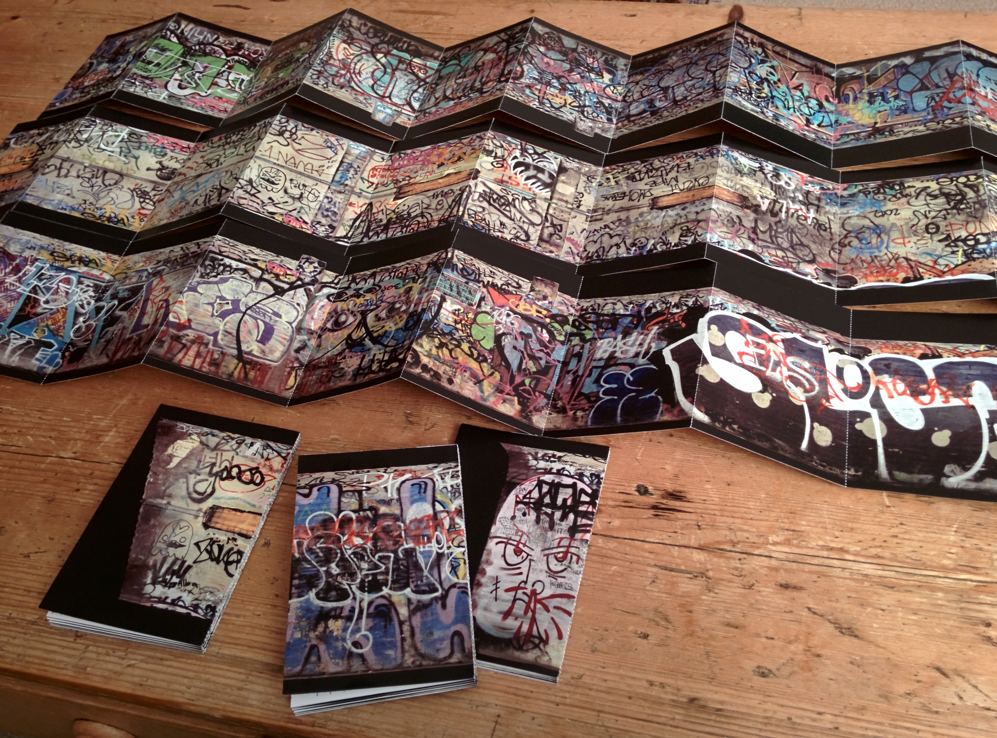
The reconstruction approach combines thousands of photographs, using hundred of hours of processing time to render them into a single 3D model. At the final count, the tunnel utilised more than 40 gigapixels of image data to produce a super-high resolution reconstructed surface. This final reconstruction has been used to create an interactive 3D iPad app, as well as a fold-out printed map of the walls and ceiling of the space.
The App allows visitors to walk through the length of the tunnel and zoom in to examine an area in high-detail. On top of this, Harle has added virtual storytellers and a time-lapse feature to bring the app to life: with the help of its local denizens, the tunnel is fleshed out through guided tours and stories, moving through the space and punctuated by gestures toward their favourite parts. In addition, by taking multiple captures months apart, Harle is able to breathtakingly transform the tunnel in the midst of his own tour, showing the striking transitions between different points in its history.
The sections of the printed map unfold out over 6 metres, printed in high-resolution to maintain the legibility and impact of the tunnel’s many vivid details. The booklet shows the tunnel as it was in early 2014.
Discussing the project, Harle explains: “I don’t believe in the preservation of graffiti – like projects to protect Banksy works with glass boxes. I think the dynamic, ephemeral aspects of graffiti are part of what make it so exciting. Having said that, graffiti is an incredibly important record of vibrant cultural expression, and it deserves to be conserved through ‘digital heritage’ projects like this.”
This project is the precursor to the next stage of Harle’s research; working with archaeologists and computer scientists at the University of Western Australia, and local communities in Pilbara and Kimberley to explore similar approaches to documenting rock art, supported by the Australia Council for the Arts.
“As an art technologist, I’m keen to go beyond the clinical feel of many recent site scanning projects, and work with approaches of evocative spatial storytelling from computer games, video, and theatre. This project attempts to do that.” He says.
The project was made possible through the generous support of Marrickville Council.
Device requirements
Compatible with all iPads.
Availability and pricing
Starting March 3rd, the Trafalgar St Tunnel App is available from the App Store entirely free. Visit www.itunes.com/appstore/.
Links to download the app
Trafalgar St Tunnel tour for iPad
Visit the Tactical Space Lab’s website for videos, screenshots and additional resources.
About Tactical Space Lab and Josh Harle
Tactical Space Lab is a Sydney-based art technology research centre founded in 2013 by Dr Josh Harle to further refine technologies and approaches developed as part of his doctoral thesis.
Josh Harle is a multidisciplinary researcher and new media artist, investigating spaces generated by emerging technologies, our encounters with the world through them, and their social consequences. He graduated with honours in Computer Science at University of Reading, UK, Philosophy at University of New South Wales and Fine Art at the College of Fine Arts, Sydney. In 2013 he completed a doctoral thesis investigating virtual and augmented space with an Australia Research Council APAI linkage grant with the New South Wales government’s Emergency Information Coordination Unit.
Harle’s practice explores the contemporary use of digital technologies to map and make sense of the world. His works take various established and emerging mapping technologies – laser scanning, photogrammetry, geolocation tracking – and re-appropriates them as expressive mediums, altering their outcomes to emphasise an affective element which is normally absent.
He has exhibited internationally in Berlin, Beijing, London, Vienna, New York, and Sydney. In 2015 he will complete an Australia Council ECAP grant-supported residency at the University of Western Australia’s Archaeology department, working with archaeologists and local communities in Pilbara and Kimberley to produce virtual tours of vulnerable rock art sites.
Become a fan on Facebook
Follow Tactical Space Lab on Twitter: @tacticalspace
Media Contacts
Dr Josh Harle
0491 155 985
josh.harle<at>gmail.com